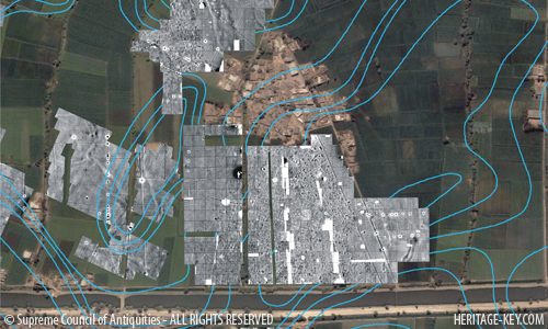
 Egypt’s Cultural Minister Farouk Hosni announced today that the Austrian mission at Tell el-Daba has located the southern suburban quarters of the ancient city of Avaris, the capital of the Hyksos in the Second Intermediate Period (1664-1569 BC). The excavation team found this area using a combination of magnetometry and resistivity surveys.
Dr. Zahi Hawass, Secretary General of the Supreme Council of Antiquities (SCA), said that the computer-generated images of the city, which is still buried under the ground, show a very detailed layout of ancient Avaris. Several architectural features including houses, temples, streets, cemeteries and palaces can be seen. The team has also been able to make out the arrangement of neighborhoods and living quarters
Using such a special scientific survey to locate such a city is the only way to gain a better understanding of such a large area at one time, Hawass pointed out.
Tell-el Dab’ais strategically placed, giving whoever controls it access to the Sinai, Levant and southern Egypt. It was abandoned for a time, after the Hyksos were driven out of Egypt. It was rebuilt during the 18th dynasty of Egypt. It included three palaces, indicating that it was used by Egyptian royalty. The most astonishing finds so far were the Minoan frescoes that decorated two of the palaces. These depict bull-leaping scenes. They are similar in many respects to the frescoes painted at the Palace of Knossos in Crete.
|
|
Click the (+) and (-) buttons to zoom in and out of this image, or double click.
Drag the image with your mouse to move to a different area.
Dr. Irene Forstner-Mller, Director of the mission said that approximately 2.6 square kilometers have been investigated using a combination of geophysical survey and excavation.
She explained that the aim of the magnetometric and resistivity surveys were to define the borders of ancient Avaris. The team has succeeded in identifying a collection of houses and a possible harbor area. A series of pits of different sizes are also visible but their function has not yet been determined.
Magnetometry and resistance tomography form just two of the new techniques being employed by archaeologists when undertaking geophysical survey and sub-surface investigations who also implement topographic mapping, drill coring, GPR and laser scanning, indicating how technology is changing the trade.