Leptis Magna, which was opened to the public in 2005, represents some of the finest ruins of the Roman age. London-based professional photographer Herb Schmitz recently visited the area and took some fantastic images, and you should watch Heritage Key’s fascinating video interview with Herb as he shares some of his thoughts on his visit to this Libyan treasure. A view you most certainly don’t get to see very often is the satellite view, looking down onto these impressive Roman remains, and the town that has built nearby it. Thanks to Geoeye who have kindly contributed this amazing high resolution aerial image of the Leptis Magna site laying next to the lush blue ocean of the Mediterranean Sea, we can zoom in close and see this culture-rich area.
Leptis Magna is a hidden treasure that has only just opened up to the world, having recently been declared a UNESCO World Heritage site. Several new discoveries have been made here in the past decade, and it’s one of the most prominent Roman sites in the North African region. The site is a personal favourite of the travel writer Ethel Davies, and boasts several key structures that were crucial to Roman society.
So what can you spot in the below image?The following famous landmarks are all in there:
The Arch of Septimius Severus is named after the Roman emperor Septimius Severus who was born in Leptis Magna. He is credited with stabilising the empire after the chaotic 193AD Year of Five Emperors when the ruler changed several times. Although some of the friezes were moved into a nearby museum, many of them remain on the Arch. The Arch is a key landmark of the city, and anybody approaching from the outside would immediately be greeted by it’s architectural splendour. There are several other arches in the area too including the Arch Tiberius, Arch of Trajan, Arch of Anonious Piud and Arch of Marc Aurillus.
|
|
Click the (+) and (-) buttons to zoom in and out of this image, or double click.
Drag the image with your mouse to move to a different area.
The Hadrianic Baths are one of the oldest structures in Leptis Magna to have been constructed from marble.Only the baths of Carthage were bigger than the Hadrianic Baths, and they were constructed in a somewhat modest, but still stunning, architectural style. The baths are complete with dressing rooms, and multiple pools made for both hot and cold water.
New Satellite Images Coming Each Week
Each week, Heritage Key will be showcasing high resolution satellite photography of Ancient World sites from across the globe, courtesy of GeoEye!
You can see last week’s stunning aerial image of the Pyramids and Sphinx of Giza.
Be sure to check back each week to see which Heritage site we cover next.
Also of interest is the Nymphaeum, which is located just outside the baths. This impressive fountain is located at the end of the Colonnaded Street and is formed of a semi-circular facade supported by columns, flanked with a bowl at the base in which the water collects. As the other end of the Colonnaded Street is the Severan Harbour, protected by a lighthouse.
Adjacent to the baths is the Palaestra, which was a gymnasium area that was often used by wrestlers.The space was a large open court where people could play ball, go running, weight lift or even play dice! They would then proceed to cleanse themselves in the baths.
The Amphitheatre was a Roman institution, and is completed built into the depressed topography of the land. Although located a kilometre outside the city, it had a capacity of 16,000 people and would cater for everything from gladiator events to wild animals.
 Part of the site contains the Old Forum, which is the site of the Old Basillica and Old Forum Church of Leptis Magna. Many of the remains in this area date from around 0AD, and were temples of the Roman religion; Leptis Magna did not convert to Christianity until later, and new structures were built to account for this, such as the Severan Basilica. There are many temples in Leptis Magna, including the Temple of Liber Pater, the Temple of Rome &Augustus, the Temple of Hercules, Temple of Jupiter Dolichenus and the Temple of Di Augusti.
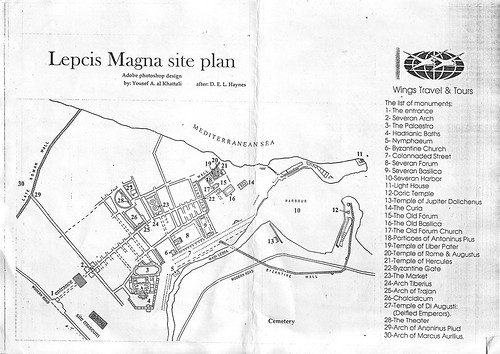
If you’re stuck for identifying them apart, then have a look at the plan of Leptis Magna on Miklos Kiss’ Flickr photostream, which highlights all the key sites, so you can zoom in on this fantastic high resolution image and pick out all the wonders of Leptis Magna.
The Satellite Image is courtesy of GeoEye.


