The Canopic Chest of King Tut was recently featured in a video with Dr Janice Kamrin, as she walks around the Egyptian Museum in Cairo, and explains what this beautiful artefact would have been used for (Skip to the video by clicking here). As one of the treasures of the Cairo Museum, it was photographed in stunning detail by the established Egyptology photographer Sandro Vannini, and the images are bought to the Internet by Heritage Key. Discovered in the Tomb of King Tutankhamun (KV62), it is one of several Egyptian alabaster artefacts that were found by famed explorer Howard Carter.…
-
-
Luxor, Egypt is one of the most culturally rich parts of the world and is often described as the “World’s Greatest Open Air Museum” for all the various tombs, temples and monuments in the area. Luxor is close to the site of the ancient city of Thebes, the capital of the New Kingdom and famed for its luxurious standards of living and high social order. The city served as an important trading route, and the base of political power in Egypt which made it a favourable destination for Pharaohs and nobles to be buried in tombs. The vastness of the…
-
Seti I’s reign over Egypt is thought to have lasted between 13 to 20 years, and during this time he opened the kingdom up to trade with foreign nations and committed to the development of construction projects. This led to stability which united the country after the fragile rule of the previous Amarna kings. The sheer number and scale of building projects thatSeti I oversaw during his reign would go on to be one of the greatest artistic periods in Egyptian history. One of Seti I’s major accomplishment of the era was the completion of the Great Temple of Abydos,…
-
Leptis Magna, which was opened to the public in 2005, represents some of the finest ruins of the Roman age. London-based professional photographer Herb Schmitz recently visited the area and took some fantastic images, and you should watch Heritage Key’s fascinating video interview with Herb as he shares some of his thoughts on his visit to this Libyan treasure. A view you most certainly don’t get to see very often is the satellite view, looking down onto these impressive Roman remains, and the town that has built nearby it. Thanks to Geoeye who have kindly contributed this amazing high resolution…
-
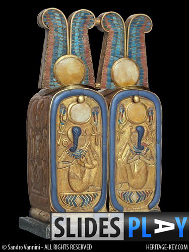
The Cartouche Cosmetic Box is one of numerous artefacts found inside the Tomb of King Tutankhamun (KV62) by famous Egyptologist Howard Carter. The discovery was made in the sarcophagus itself according to Carter, although it’s possible that the artefact was actually found in between the two outer shrines, as other cosmetic boxes were. At a height of just 16cm and width of 8.8cm, with a depth of 4.3cm, the Cartouche Cosmetic Box bears several symbols intricately carved on it. This beautiful artefact is just one of many of the Treasures of the Cairo Museum, the very museum which Dr Zahi…
-
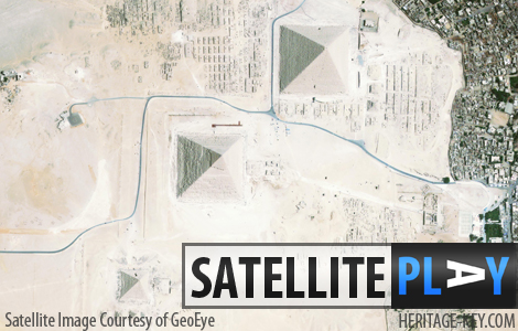
The Pyramids of Giza at the Giza Plateau, Egypt, are one of the most famous sights in the world. It’s probably photographed from every possible angle from the ground, but often do you see it from above?Sure, Google Earth might give you an insight into aerial photography, but GeoEye has kindly given Heritage Key amazing satellite imagery at a high resolution, allowing us to see the pyramids as if we were in the space shuttle (or an alien space craft). Giza is, of course, home to the iconic Great Pyramid of Giza. Towering at 138.8 metres, it is the only…
-
A video featuring Dr Farouk Gomaa was recently featured on Heritage Key as he explains his progress on archaeological excavations being carried out in el-Assasif, Thebes at the site of TT34 – the Tomb of Montuemhat. Dr Farouk Gomaa explains that the search in the tomb continues for the burial chamber of the diplomat Montuemhat, which has yet to be located. The mysteries ofThebes are uncovered in a new book featuring photography from the renown Egyptology photographer Sandro Vannini in the publication “The Lost Tombs of Thebes:Life in Paradise” authored by Dr Zahi Hawass. The excavations at TT34 were photographed…
-
Calcite was a popular material used in ancient Egyptian times as the stone’s cool surfaces meant that the contents, such as perfumed fats and unguents, would be better preserved. However, perfumed fats were a luxury item and popular with grave-robbers in ancient times as they were easy to carry, and difficult to identify as being from a tomb. The Tomb of King Tutankhamun (KV62) was believed to have been raided of about 350 litres of perfumed fats and unguents, according to an estimate by the famous explorer Howard Carter! One of the most beautiful artefacts from King Tutankhamun’s tomb was…
-
The Antechamber of the Tomb of Seti I (KV17) is a small room which precedes the burial chamber, and features on its tomb walls scenes depicted from the Book of the Dead. The renown photographer in the field of Egyptology, Sandro Vannini took several photographs throughout KV17, including the First Pillared Room which we featured recently. This week we look at the tomb engravings of the Antechamber, and who they depict. Sandro’s photography is the finest way to see Seti I’s tomb, after years of excavation have left it in a poor state of disrepair and leading to its closure…
-
The Tomb of King Tutankhamun (KV62) contained many calcite jars and vases, but most were located in the antechamber and the annexe. However, the Cosmetic Jar with Recumbent Lion was found between the walls of the first and secondshrine of King Tut, in the burial chamber, suggesting it may have had more significance. Perhaps used in the funeral ceremony, the jar was found with residues of a costmetic inside – a blend of vegetable resin and animal fats.The Cosmetic Jar was one of the many artefacts from KV62 originally discovered by famous explorer Howard Carter, and photographed at the Egyptian…


