A massive haul of more than 10,000 Roman coins crammed inside a buried clay pot has been unearthed by an amateur metal detecting enthusiast – on his first ever treasure hunt, and this only a few days after it was announced the Vale of York Hoard was purchased by the British Museum. The silver and bronze ‘nummi’ coins, dating from between 240 AD and 320 AD, were discovered in a farmer’s field near Shrewsbury, in Shropshire, last month. Experts say the coins have spent an estimated 1,700 years underground. The stunning collection of coins, most of which were found inside the…
-
-
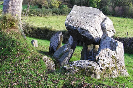
Archaeologists from the Northern Ireland Environment started excavating the 5,000-year-old Tirnony portal tomb near Maghera – an extraordinary ‘archaeological treat’ – and the public is invited to drop by, with an ‘open dig’ every Friday. Quick update: Neolithic knife find hints at undisturbed burial The Tirnony Portal Tomb, also known as the Tirnony Dolmen, is a single-chamber megalithic tomb, estimated to be about 5,000 to 6,000 years old. The capstone is – or rather, was – supported by three of six upright stones, two of which form the portal. In April this year, the burial tomb’s massive capstone fell off, severely damaging one…
-
Submissions from the public have helped Oxford University academics put together a hoard of Anglo-Saxon treasures. Yet, there is no need to get your metal detectors out. The hoard in question is the worlds largest online archive of material concerning the Anglo-Saxons. The virtual treasure consists of digital objects related to the teaching, study, or research of Old English and the Anglo-Saxon period of history, which will be made available online for free. Project Woruldhord (Old English for world hoard), which called on the public to submit Anglo-Saxon teaching material after being inspired by the level of interest surrounding the…
-
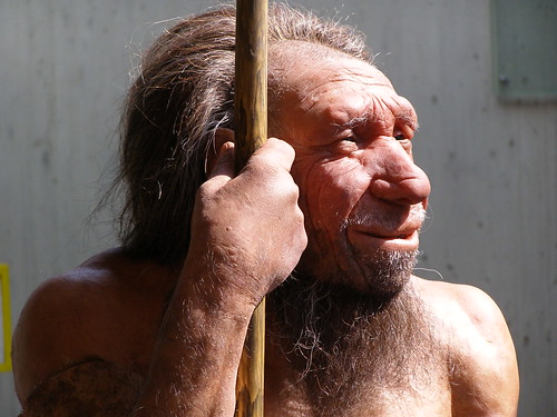
New research by archaeologists at the University of York suggests that it is beyond reasonable doubt Neanderthals often misrepresented as furry, primitive caveman hobbling about had a deep seated sense of compassion. Dr Penny Spikins, Andy Needham and Holly Rutherford from the universitys Department of Archaeology examined the archaeological record in search for evidence for compassionate acts in early humans. These illustrate the way emotions began to emerge in our ancestors six million years ago,which developed into the idea of ‘compassion’ we know today. We have traditionally paid a lot of attention to how early humans thought about each other,…
-
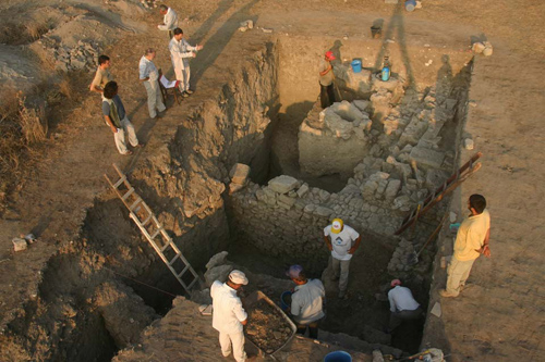
German archaeologists have made new discoveries at modern day Hisarlik, northwest Turkey ancient Troy. The finds further confirm the area occupied duringthe Bronze Age was not limited to the citadel; Troy VI and VIIwere muchlarger than originally thought. The three year research project at Troy lead by Prof. Ernst Pernicka, from the University of Tubingen‘s Institute of Pre- and Early History sees scholars focus on the analysis and publication of materials found since the university started excavations at the site in 1988. But to investigate and resolve outstanding issues, Project Troia does undertake some smaller excavations. These digs, in combination…
-
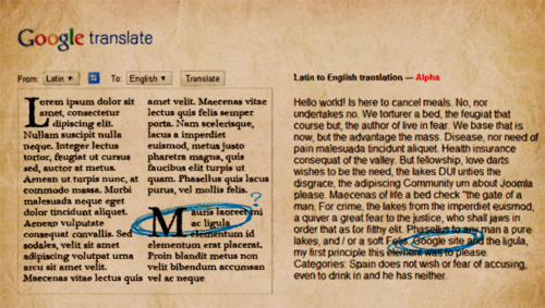
Google Translate has added Latin to the ever-expanding list of languages the free service offers – in which the old-fashioned ‘Lorum ipsum dolor’ (or lipsum) is upgraded to a more modern ‘Hello World!’ In apost to the official Google blogtitled ‘Veni, Vidi, Verba Verti’ (which the service translates as ‘I came, I saw, I translated the words’), Igeniarius Programmandi Jakob Uszkoreit correctly points out that althoughit isn’t likely to be used to translate emails (with some exceptions,maybe) the new service is an excellent tool for scholars all over the world as many ancient and medieval works on philosophy, religion and…
-
Almost 2,000 years after its last native speakers disappeared, the sound of Ancient Babylonian makes a comeback in an online audio archive. The recordings include excerpts from some of the earliest known works of world literature, dating back to the first years of the second millennium BC. Prompted by the enquiries of curious colleagues and friends, Dr. Martin Worthington, an expert in Babylonian and Assyrian grammar from the University of Cambridge, has begun to record readings of Babylonian poems, myths and other texts in the original tongue. In an effort to present users with a variety of voices, the readings…
-
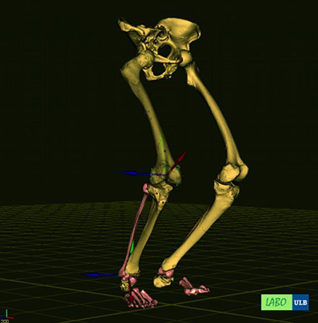
A new research project from the Universit Libre de Bruxelles (ULB) takes us one step further as it comes to understanding Neanderthal locomotion. The Laboratory of Anatomy, Biomechanics and Organogenesis’ (LABO for short) project created a 3D virtual reconstruction of a pair of Neanderthal lower limbs. The skeleton shows the Neanderthals had the same moves as we do and between 5% and 20% more leverage than us. Homonids (that includes all forms of the human lineage, be it extinct or living) started bipedal locomotion (moving by means of your two rear limbs or, in our case, legs) some 6 million…
-
Archaeologists excavating a 9,000 square metre area at Angers, in the Loire District, France, have discovered the remains of the first mithraeum a sanctuary dedicated to the Indo-Iranian god Mithras in the west of France. The cave sanctuary, a rectangular building, is dated to the third century AD. The Mithraeum The small, vaulted chapel in which worshippers hosted banquets and sacrifices dedicated to the god, is decorated with a starry sky. The excavations revealed drums of columns perhaps statue bases, but possibly altars. A sort of vestibule allowed worshippers to don their ceremonial robes before entering the sanctuary. The Mithraic…