Category: Ann - Part 6

Sagalassos Archaeological Project Digs Up Oldest Roman Baths in Asia Minor

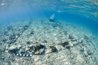
Sagalassos Roman Baths Turkey AnatoliaAt the ancient city of Sagalassos, Turkey, archaeologists have discovered the oldest Roman baths in Asia Minor known to date.

The new find means the Capito Baths in Miletus, built during the reign of Emperor Claudius (41-54 AD),have to concede theirposition as the oldest known Roman bathing complex in Anatolia.

Oldest Roman Bathsin Asia Minor

The ‘Old Bath’ was discovered at Sagalassos, an ancient city from Hellenistic and Roman times in southwestern Turkey. They were locatedbelow the previously unearthed Imperial Baths, dated to120-165 AD.

The newly discovered bathing complex is much older and smaller than the Imperial Baths which have a surface area of more than 5,000 square metres and is dated to 10-30 AD, though the Old Bath was probably built somewhat earlier, during the reign of Augustus or Tiberius.

The approx. 3 metre high south wall of the heating room of the bathing complex. Warm air was blown under the floor of the middle apsidal space or ‘caldarium’ (hot water pool).

The Old Baths measure 32.5 by 40 metres and are far better preserved than was originally thought. The complex walls must have been at least 12 metres high, of which 8.5 metres remain erect today.

When Hadrian selected Sagalassosas the centre of the Imperial cult for all of Pisidia, to which the city belonged this included the organisation of festivals and games (agones).

These attracted thousands, making a new urban infrastructure necessary. In order to accommodate the Pisidian visitors to the events, the Old Baths were replaced by the larger Imperial Baths.

Roman Style Bathing

The Roman bathing habits consisted of a succession of a warm water pool, a hot water pool and a cold water pool.

Each pool of these pools (a ‘piscina’ or ‘natatio’) was housed in a separate space; a tepidarium, a caldarium and a frigidarium, respectively.

The Sagalassos Archaeological Research Project

The Belgian Sagalassos Archaeological Research Project directed by Professor Marc Waelkens from the University of Leuven this past summer (photographs from the 2010 season) also revealed the faade of an important public building dating from the reign of Emperor Augustus (25 BC – 14 AD). It may have been the town hall of Sagalassos.

The team also concluded that the triumphal arch, until now thought to pay tribute to Caligula, was actually erected in honour of his uncle and successor Claudius (41-54 AD) and Claudius brother Germanicus, Caligulas father.

The reconstructed Antonine Nymphaeum, at Sagalassos' Upper Agora. The water drops down from a height of 4.50 metres, into a 81 cubic metres reservoir.

Anastylosis: Antoine Nymphaeum

At the end of this seasons excavations, an Antonine Nymphaeum was inaugurated at the Upper Agora of the Sagalassos site.

The reconstruction of the fountain was an ‘anastylosis’ project, whereby a structure is restored using the original architectural elements to the greatest degree possible.

The monumentwas constructed around 160AD,using 7 different kinds of stones. The restored fountain contains more than 85% of its original building blocks. Where needed for stability reasons, missing stones were replaced by blocks fashioned using antique technologies; the same way they would have been made 2,000 years ago.

Now, the9 metres high and 28 metres longAntonine Nymphaeum,is againfed by one of its original water canals. It collapsed when earthquakes destroyed Sagalassos in the7th century AD.

‘No ceremonial burial for the Iceman’, respond Otzi researchers

The Chalcolithic Iceman was found on lying on his stomach, with his arm in an ackward position. Possibly, his companions tried to remove a arrowhead from his shoulder. - Image courtesy the South Tyrol Museum of ArchaeologyIn his article The Iceman as a burial appearing in Antiquity 84/2010, the archaeologist Alessandro Vanzetti of Romes La Sapienza University and his coauthors reconstruct the position of the Iceman at his place of discovery on the Tisenjoch pass in South Tyrol, Italy. From this and based on his botanical investigations, he draws the conclusion that the Iceman did not die at the site of the incident: rather he died in the spring within his valley community and only later, in September, was brought up to the Tisenjoch and buried there.

The team researching tzi has now responded to Vanzettis claims, in a statement issued by the South Tyrol Museum of Archaeology. They point out Vanzettis scenario has already been discussed numerous times in the past, and say it displays fundamental weaknesses in its chain of argument and its archaeological context , meaning that the hypothesis of a burial on the glacier, is unconvincing.

The conservation and research team does do not regard pollen or the distribution pattern of the associated finds as suitable for analysing the cause of death, the possible body changes after death or the funeral rites.

From an archaeological viewpoint, they say, it should be noted that this body from the Copper Age found on the Tisenjoch represents a unique discovery. South American cultures perform burials on mountains or at altitude, but there are no known comparable cases in the Alpine region. On the contrary, during the Copper Age individual burials in ordinary cemeteries close to settlements were the rule. Even in the case of highly complex funeral rites (individual or collective graves, primary or secondary burials, interment or cremation), there are no indications of burials taking place so far away from settlements.

Regarding Vanzettis ethnohistorical argument that, in Tyrol, the deceased were preserved after death and only carried over the mountain passes to cemeteries after the spring thaw, the archaeologists point out that this can be explained by the system of Christian churches with cemeteries and the feudal power structures of the Middle Ages. In such cases the dead were buried as soon as possible in the appropriate cemetery according to church law. The object was however to bring the dead to the cemetery in the village, not from the village to the mountain. Suggesting an analogy between this Christian era custom of keeping the dead and the burial practices in tzis Copper Age, the team says, is pure speculation.

The Similaun is a 3606 meter high mountain in the tztal Alps in Tyrol on the border between Austria and Italy. - Image copyright the South Tyrol Museum of ArchaeologyIf, as Vanzettis article proposes, the Iceman died in a valley location in April and was only carried up the mountain in September, there would be evidence of greater decomposition processes as well as insect infestation, despite any attempts at mummification.

The research team says there is no proof of these, so we can assume that the body must have lost much by way of fluids but was rapidly frozen and protected by a covering of snow or ice.

This special situation resulted in the mummifying of the Iceman, unique in the world, with the fluids in his tissues remaining preserved. This preservation is based on a freezedrying process and cannot be explained by dry mummification, as Vanzetti conjectures.

The most important forensic evidence for the fact that the loss of body fluid could not have occurred anywhere else than at the place of discovery is the position of the left arm and the uninterrupted stream of blood from the wounded artery via the wound path to the skin. This clearly proves that the position of the arm is as it was exactly at the time of death, while the blood was still circulating. As the corpse lost its rigidity it would have been very easy to lie the arm next to the body.

Vanzettis counterargument is that the body was buried intact on the glacier and that it only slid downwards as the glacier melted, with the arm moving to its current position in front of the chest. This is inconceivable if, as the authors previously state, the Iceman had already died a few months before and been mummified. The rigid arm could then no longer be brought into its position without causing substantial damage either to it or to the shoulder. All of the Icemans joints are in fact in their anatomically correct position. It is therefore not possible for the intact mummy to have been transported up to the glacier.

It wasnt until 2001, prompted by the discovery of an arrowhead lodged in tzi’s shoulder, scientists discovered the Iceman died a violent death. Further research revealed bruises and cuts, as well as evidence the Tyrolean Iceman received a blow to the head.

It is thought to be unlikely tzi was alone on the Similaun mountain at the time of his death possibly his companions have attempted to save him.

The research team (which includes Dr Zinc who worked on the King Tut Unwrapped DNA project) is currently reexamining the glacier mummy and for the first time his DNA. They promise to publish their data analysis as well as the resulting conclusions by next year, in time to celebrate the 20th anniversary of tzi’s discovery.

Fiery Pool: The Maya, the Mythic Sea and the Turtle

'Fiery Pool, The Maya and the Mythic Sea' opens this weekend at the Kimbell Art Museum, Fort Worth, Texas. - Photo Courtesy Peabody Essex Museum, Copyright 2009 Joroge Perez de Lara (CLICK TO SKIP TO THE SLIDESHOW)After a successful stay at the Peabody Essex Museum, ‘Fiery Pool: The Maya and the Mythic Sea’ opens this weekend at Forth Worth’s Kimbell Art Museum. The exhibition offers a new interpretation of the ancient culture, beyond the traditional view of the Maya as a land-based civilisation.

Expect supernatural crocodiles breathing forth rain; cosmic battles taking place between mythic beasts and deities; and art works adorned with shark teeth, stingray spines, sea creatures and waterfowl all part of the new and vivid picture the exhibition paints of the Maya world view: the Maya did not just navigate river and streams, they navigated the cosmos.

They had this fundamental notion of the Maya world as a giant turtle, floating on the primordial sea. Not an everyday day turtle, floating in the pond this is the cosmic turtle on which all of us float, explains Stephen Houston, Professor at Brown University, who organized the exhibition together with Daniel Finamore, Curator at the Peabody Essex Museum (PEM).

Also presentaround 3100BC were:

  • Newgrange & Skara Brae
  • Otzi the Iceman
  • The Minoans
  • Egypt’s first mastabas
  • Stonehenge earth bank &ditch
  • Cuneiform

13.0.0.0.0 4 Ahaw 8 Kumk’u (August 11, 3114 BC*), is the mythicaldate is recorded throughout the entire Maya area as the beginning of the current creation, when -as described inthePopol Vuh creation myth- themaker let made the earth appear where there before was only the calm sea and the great expanse of the sky.

However, it must be noted, according to ‘accepted history’ (and wikipedia) the first clear Maya settlements weren’t established until approximately 1800 BC on the Pacific Coast – and the oldest discoveries of Maya occupation discovered so far (at Cuello, Belize) have been carbon dated to around 2600BC.

Fast forward to the Classical period (300-900AD) -whenthe civilization reached its peak – and ‘Maya’ ment hundreds of cities across Mexico and Central America andtheir territoryreached as far as the Gulf of Mexico, the Pacific Ocean and the Caribbean Sea. The Maya practised a complex religion and used a refined pictorial writing system composed of more than 800 glyphs.

While today 90% of these glyphs are understood (an introduction on ancientscripts.com),it was only in the late eighties that the glyph for ‘sea’ was identified. Until then, the importance of the sea in Maya culture had not been fully understood. The identification of this glyph, translated literally as ‘fiery pool’, brought to attention how important the oceanic, inland and atmospheric waters were for the Maya’s existence resulting in the exhibition ‘Fiery Pool’ and its companion book.

Click the images to see a larger version.

In 1986, the Kimbell Art Museums landmark exhibition The Blood of Kings: Dynasty and Ritual in Maya Art shed new light on the importance of dynastic lineage and blood sacrifice to the Maya, commented Eric Lee, director of the Kimbell Art Museum.

This exhibition is the next important chapter in Maya research, and I am thrilled that the Kimbell Art Museum will showcase it.The museum has dedicated part of its website to the exhibition, find it at kimbellart.org/mayaand try their (addicting) Glyphs game.

Over 90 works, focusing on the sea as a defining feature of the spiritual realm, offer insights into the culture of the ancient Maya. The artefacts, displayed in four sections,reflect the broad range of media used by Maya artists: massive, carved stone monuments and delicate hieroglyphs, painted pottery vessels, sculpted human and animal figurines, and an assortment of precious goods crafted from jade, gold and turquoise.

Water and Cosmos

Surrounded by the sea in all directions, the ancient Maya viewed their world as inextricably tied to water, an idea that is explored in the first section of the exhibition, Water and Cosmos. More than a necessity to sustain life, water was the vital medium from which the world emerged, gods arose and ancestors communicated.

A limestone panel from Cancuen, Guatemala, is an exceptional example of Maya sculpture, depicting a ruler known as Tajchanahk, TorchSkyTurtle, seated on a water-lily throne in the royal court while simultaneously inhabiting the watery realm. For the Maya, the realms of earth, sea, sky and cosmos may have been perceived as flowing into each other rather than as distinct territories of being.

Creatures of the Fiery Pool

The world of the Maya brims with animal life animated, realistic and supernatural all at once. The objects in the second section, Creatures of the Fiery Pool, portray a wide array of fish, frogs, birds and mythic beasts inhabiting the sea and conveying spiritual concepts.

An effigy of a Caribbean spiny lobster is the only known Maya representation of the creature, excavated in 2007 from Lamanai, one of the oldest sites in Belize. It dates from the turbulent early colonial period, when traditional Maya life was disturbed by the incursion of Spanish soldiers and missionaries.

Navigating the Cosmos

The section Navigating the Cosmos explores water as a source of material wealth and spiritual power. All bodies of water rivers, cenotes and the sea were united, and connected the land of the living to the underworld.

A magnificent head of a deity with characteristics of the Sun God is one of the most exquisite works discovered in the Maya world. It was found in the tomb of an elderly man, likely cradled in his arm upon burial at the sacred site of Altun Ha. Weighing nearly ten pounds, the sculpture was created from a single piece of jadeite, the colour of which was directly associated with the sea.

Birth to Rebirth

The final section of the exhibition, Birth to Rebirth, addresses the cyclical motion of the cosmos as the Maya pictured it. The sun rose in the morning from the Caribbean in the east, bearing the features of a shark as it began to traverse the sky. Cosmic crocodiles exhaled storms and battled with gods of the underworld.

An elaborate ceramic incense burner from Palenque (where they had an ingenious water system), Mexico, portrays a deity central to a creation myth. Water-curls on his cheeks and ear ornaments, which link him to the rain god (Chahk), speak of his connection to the watery world. A shark serves as his headdress, topped by a toothy crocodile. From this censer, ritual smoke curled through the city of Palenque, suffusing it with scent and mystery.

‘Fiery Pool: The Maya and the Mythic Sea’ at the Kimbell Art Museum runs from Sunday August 29 until the end of the year and is accompanied by an illustrated catalogue, available at the museum.

On October 10th, the museum invites everybody to experience the rich culture of the ancient Maya at ‘10.10.10, Celebracion de los Mayas’, a free family festival with Maya-inspired art activities, film and live music. Admission to the exhibition will be free that day.

Taking your kids to see ‘Fiery Pool’? You want to download (and print) the exhibition discovery kit from the PEM website.

The exhibition ends January 2, 2011. ‘Fiery Pool’ will then travel toSaint Louis, where it opens at the Art Museum February 13th.

Stonehenge Acoustics: England’s First Ministry of Sound?

No electrically powered music devices (read soundsystems) are allowed at the Stonehenge Solstice celebrations, but that doesn't mean there's no music... - Click to watch the videoLondon-based nightclub Ministry’s motto of sound system first, interior design second, lights third made them one of the most famous gathering places for those who worship bass.

But how did those conceptualising Stonehenge plan to enchantthe Neolithic congregate?

Rupert Till, an acoustics and music technology expert, asserts the stone circle would have created a perfect (early design) amplifier – making Stonehenge the place to be from the Stone Age onwards.

Professor Tillsays Stonehenge when it was in perfect shape would have worked perfectly to resonate sound, creating trance-like music which would have aided rituals and worship at the site.

To test this theory, Dr Till and fellow acoustician Bruno Fazenda recorded popping balloons at the Wiltshire monument:

Video: Summer Solstice at Stonehenge

Video and photographs from the Stonehenge Summer Solstice 2010 celebrations. The music ‘Drunken Druid’ is by Druidicca, and the pretty statue you see during the sunrise fragment is the ‘Ancestor’. Of course, King Arthur is featured in the video as well (more about this video).

This was not some bizarre pagan ritual. It was a serious attempt to capture the “impulse response” of the ancient southern English stone circle, and with it perhaps start to determine how Stonehenge might have sounded to our ancestors, explains Trevor Cox on the New Scientist website.

The scientists used this recording to build a virtual model that allows to compute how any sound would sound within the megalithic monument.

Applying the model to a drum beat, they found that there is a noticeable difference:

There is more reverberation or ringing to the drumming sound thanks to the reflections off the stones.

What’s more, the tonal balance of the sound is entirely different: it has become much deeper, as if the treble has been turned down.

According to Dr Till, the design didn’t take place by chance. He points out the acoustic properties are too specific. The stones and lintels are all curved which helps to reflect the sound perfectly and when Stonehenge’s builders placed a stone in a particular place, they would have noticed a change in sound.

Some spots in the site produce an extremely peculiar acoustic effect, making them excellent locations for whoever was leading the gathering to position him (or herself), demonstrated in the video on the right (it does remind of early Autechre).

Solar Alignment First

Maybe I’m refusing to think outside the box or circle, in this case here, but my best guess would be that for those who contributed to Stonehenge, acoustic qualities wasn’t the first thing on their minds.

Rather, they must have opted for astronomical alignment first, we like circles (and Euclid won’t be around for at least another thousand years) second and many still unknown factors (after all, Stonehenge is a complex site, constructed in several phases) third and forth and fifth.

Moving about 30 tons of Sarsen stone, just to get a different pitch?It is more likelythey’d optfor upgrading the musical instruments or the ‘Shaman’ used? Taking ancient amphitheatres into account, a bank around the construction might have also improved the sound, yet Stonehenge is the only ‘henge’ which had to do with just a ditch? Recent research indicates that there were more than just a few gathering at and possibly in the stone circle. How would their physical presence affect the modulation?

Although Druidicca’s live performance at the Stonehenge Summer Solstice(as seen in this video)is something memorable, take my advise:visit Stonehenge for the sunrise, and Ministry for the bass.

Maya Pool the Size of a Football Field Discovered in Uxul, Mexico

The German-Mexican excavation team exposes the floor of the Maya pool, covered in ceramic shards. These would have sealed the reservoir. - Image copyright Institute for Ancient American Studies, University of BonnArchaeologists digging at the ancient Maya city of Uxul, Mexico, havelocated an artificial lake the size of a football field. The two metres deep pool its floor a mosaic of ceramic shards was constructed about 1,500 years ago.

Uxul is located on the Mexican Yucatn Peninsula, near the Guatamalan border and only twentysix kilometres southwest of Unesco World Heritage Site Calakmul. German and Mexican archaeologists started systematically excavating and mapping its ruins in 2009.

In doing so, we stumbled upon two square water reservoirs, each about 100 metres by 100 metres, says Dr Iken Paap from the University of Bonn.

Massive pools for storing drinking water called ‘aguadas’ are well known from other Maya cities. What makes these newly discovered reservoirs and exceptional find, is that the Uxul peoples seem to have devised an ingenious and previously unkown way to seal their water storage systems.

We’ve carried out atrial excavation, right in the middle of one of the reservoirs, explains Nicolaus Seefeld.We found that the floor, at two metres deep, was almost completely covered with ceramic shards probably pottery fragments. If it is like this throughout the entire aguada, we don’t know yet.

Click the map to see a larger version. The two artificial lakes are marked in blue on this map of Uxul's ruins. Both measure about 100x100 metres (a football field is about 90 by 120 metres.) - Image copyright Institute for Ancient American Studies, University of Bonn
Click the map to see a larger version. The two artificial lakes are marked in blue on this map of Uxul’s ruins. Both measure about 100×100 metres (a football field is about 90 by 120 metres.) – Image copyright Institute for Ancient American Studies, University of Bonn.

If so, the pools are an extraordinary find not at least because of the sheer amount of pottery needed; each of the Uxul aguadascould contain approximately ten Olympic swimming pools.

It is possible future excavations will reveal additional reservoirs. The aguadas needed to store enough water for Uxul’smore than2,000 residents to make it through the three-month dry season.

The German-Mexican excavation team alsofound Uxul’s first intact graves.

From these, and new research on the water provisions and vegetation history, we expect to gain new insights into the inhabitants of this Maya city, says Bonn University’s Dr Nikolai Grube.

All burials found so far were destroyed by grave robbers in search for pottery or jade.

Analysis of the different layers at Uxul shows it was populated throughout the different periods of Maya civilization. We excavated more than three meters deep, revealinga sequence of layersranging from the late Preclassic to the late Classic or Postclassic period,” tells Dr Paap.Inscriptionshave revealedthat around 630 AD, the city of Uxul was annexedto the kingdom of Calakmul.

The name ‘Uxul’, meaning’at the end’, was given to the city by explorers Karl Ruppert and John Denison when they tired and ill after a long expedition through the Yucan Peninsula’s rainforest discovered the ruins in 1934. Not much has changed since the thirties; Uxul is still at the end of the world, far away from modern roads and cities (photographs from the 2010 excavation season seem to confirm this).

To reach the ruins, it takes travelling 120km of jungle paths through the Calakmul Biosphere Reserve, explains Dr Iken.

A thousand years ago, Uxul wasn’t isolated at all. Excellently positioned between the great Mayan cities of El Mirador in the South and Clakmul, the city was trading as far as modern-day southern Guatemalaand the highlands of central Mexico.

History FAQ (Funny Asked Questions)

Absolute Antiquity ParodyIt is a well-known rule that search queries which lead people to your website should be dealt with as actual questions depending on the amount of people using the search query, you know that at least one person is interested in the subject (as it comes to sex andnaked belly dancers a lot of people are intrigued). Now, some people actually phrase their search query as a question (remember AskJeeves?) starting with ‘what’, ‘how to’, ‘where’, … .Often these are err.. quite original.

Here are my favourites (capitalisation and question marks added where needed) in the categories ‘General (Lack Of) Knowledge‘, ‘Dr Hawass &Chasing Mummies‘ and ‘Things I’d Actually Like to Know Too‘from the last few weeks. I’ve tried to answer all of them, yet feel free to correct me when wrong.

General (Lack Of) Knowledge

Or ‘even in these economically different time we should NOTcut back on education’.

  • How to dispose of toxic waste in ancient Pompeii? I’m sure these people can help you out. Choose ‘proposals and competitions’ from the dropdown form. If they don’t get back to you, try your luck emailinginfo@ndrangheta.it.
  • What are the chances that a whale could live in the desert? Zero. Trust me on this one.
  • Does Cleopatra really made sex with 100 men? Doubtful, where did you hear this?
  • Does Cleopatra live under the Sphinx? Not likely (unless Mark Lehner refuses to share).
  • What are the secrets of the tomb behind the pyramid?Ah yes, that tomb and that pyramid. Well, if I were allowed to tell you, it wouldn’t be a secret, would it?
  • What is Boudicca? Did youmean ‘who is’?
  • What do Mayan experts say about 2012?NASAsays it’s bullocks.
  • Was Tutankhamun an alien? No, does he look like an alien to you?! Oh, wait… .
  • The Acropolis Museum, what’s wrong with its contents?Everything is past experation date.
  • What do I need to build Chichen Itza?I believe this falls under the category ‘don’t try this at home’. If you mean using the Facebook application ‘My Empire’, just give up and STOPSPAMMINGPEOPLEwith application invites. And no, we don’t want to get involved in your maffia war.
  • What is the Noah’s ark security key? Try 1111. If that doesn’t work, call tech support to reset your ark.
  • For what was Cleopatra famous for? Was it for Sex? Well, she was also ‘the last Queen of Egypt’. It is quite possible that had something to do with it as well.
  • What can you find with a metal detector? Read that question again.
  • What causes someone to dance topless?Try C2H5OH. Often used as well are $ and .
  • What is the naked archaeologist’s hat called? You have pictures of Dr Hawass naked?!
  • What did ancient queen Cleopatra use for a body wrap? Two different brands: Mark Anthony and Julius Caesar.
  • What is the King Tut sex position? Are we missing out on something? (After googling, we are _not_.)
  • Hello, can you please find out and tell me what spring and autumn equinox’s are. Thank u. Only because you’re asking so nicely! Here you go.
  • What are interesting facts about an archaeologist? That depends on the archaeologist in question. We like Ellie a lot.
  • What is an ancient smurf? Most likely something ‘photoshopped’.
  • In what period of time were there warriors? It is generally accepted that we started bashing each other’s skulls as soon as we managed to hold a rock, so that could be from as early as 3.400.000 years ago, and still going strong.
  • How to win on the battlefield? For console or PC? Here’s some advice from Alexander the Great.
  • What does Stonehenge look like today? What about searching for ‘Stonehenge +image’? But if you really want us to tell you, it is a bunch of really standing stones, more or less positioned in a circle.
  • What is a winged genius? A statue of Greek philosopher Socrates on a Red Bull.
  • What is the significance of the recent archaeological finds in China? Can you _please_ be more specific?
  • How did the Pompeii victims turn to stone? They didn’t. The famous images of the Pompeii victims show plaster casts of the bodies’ imprints in the ashes. The deceased were burried by ash, which lithified (becoming solid rock) before the corpses decayed. The bodies then disappeared, leaving a hole behind. Filling these ‘molds’ with plaster produced the amazing ‘statues’ of the humans and animals that died.
  • King Tut died of sickle cell does this mean he was black? *sighs*
  • Did Queen Cleopatra have dreadlocks? No, she wore wigs. She wasn’t black either.

Search queries for 'chasing mummies'

On Dr Zahi Hawass & Chasing Mummies

I’ve been accused of being to critical, but clearly, I’m not the only one.

  • Is chasing mummies supposed to look real? As far as we can gather, yes.
  • What’s up with Zahi Hawass temper?Some would argueit is due to mistranslation andcultural differences.
  • Did Zahi Hawass join the illuminati? No official statement has been released by the SCA.
  • Why does Zoe pee? Wouldn’t you if you were stuck in a pyramid?
  • Is Zoe chasing dummies what university does she attend? (I’m not kidding.)
  • Does Zahi Hawass have to be on every Egypt film? Rumour goes this law should have passed months ago, were it not being blocked by the Egyptian Minister of Culture.

BONUS: What kind of hat does Dr Zahi Hawass wear on the show chasing mummies?We’re not quite sure, BUTif you travel to the Cairo Museum or visit the touring King Tut exhibition in NYC, you can purchase a replica. (I must note we also received an email requiring after the make of Kathleen Martinez’ headwear. Some marketing opportunities for travel-related clothing brands there?)

Stuff I’d Actually Like to Know Too

Some of the questions asked do make sense. I wouldn’t mind knowing the answer to:

  • Will the Philadelphia Cleopatra exhibition come to the UK?
  • Do they produce replicas of the Turin Erotic Papyrus? (There’s still room on the office wall!)
  • What is the scariest looking Greek god?
  • What did the Minoans say in Despicable Me? (I _so_ want to see that movie.)
  • What is the purpose of afterlife?
  • What are Cleopatra’s seduction secrets?
  • What happened to the Ninth Legion?(as we’re not entirely sure)
  • What country has 3 sided pyramids?

Easy Answers

  • How to get a job at the British Museum?Apply here.
  • How to defeat the kraken? Kill Medusa, usethe head.
  • What is missing from the Parthenon? The Elgin Marbles! (Well, that’s thesimplified answer, the long answer is ‘almost everything’.)
  • In what place is Tutankhamun now? We’re not entirely sure if he made it safely into the afterlife (Carter decapitating him an all that) but his mummy can be found in KV62.
  • Does the Louvre allow photography? Yes (except in the Denon wing and in front of the Venus de Milo)
  • Does it ever snow in Egypt? Yes. Pretty, isn’t it?

Homework

Teachers, recognize these questions? They were actually still numbered!Kids, I’ve tried answering them without looking on Heritage Key (or anywhere else on the internet) for theanswers, so don’t take my word for it.

  1. What were the four Germanic tribes which comprise the group we know as the “Anglo-Saxons”?
    Angles, Jutes, Saxons and err… err… ‘Fries’? Definitely not the Vikings or Normans, they settled later.
  2. What is the debate over the British Museum’s ownership and display of the Parthenon sculptures?
    Main points: a.) Was the removal legal? b.) As part of the friezes are spread over the world, shouldn’t they be made ‘whole’ again. c.) The BM once said they’d return them when the Greek had a safe place to store them, they now have the NAM. d.) ‘Who owns antiquities?’
  3. In what part of the world is most cave art found?
    Most ‘really old’ cave art is found on the European continent.
  4. Why does so much controversy surround the excavations of Heinrich Schliemann (1822-1890)?
    He ‘renovated’ the Knossos palace?

How did I do?Oh, and to theteacherasking 6. What was the capital city of ancient Britain?,is this a trick question?

If you are a history teacher or professional, what are the most absurd or entertaining questions you were ever asked? If you are a history blogger, have a look in your Google Analytics data under ‘traffic sources’ > ‘keywords’ > containing ‘what’, ‘who’, ‘does’, ‘where’or ‘aliens’and !

Traces of Lost Language and Decimal Number System Discovered in Peru

The back side of the Magdalena document shows translations for numbers from Spanish to a lost language. Photo by Jeffrey Quilter. Excavations at a Colonial Period site on the North Coast of Peru have revealed the first traces of a lost language. Sometime in the early 17th century, a Spaniard jotted down some notes on the back of a letter. Four hundred years later, archaeologists dug up and studied the paper, revealing how Peruvian natives used numbers.

The find is significant because it offers the first glimpse of a previously unknown language and number system, says Dr. Jeffrey Quilter, director of the archaeological project at Magdalena de Cao Viejoand curator at the Peabody Museum Harvard. It also points to the great diversity of Perus cultural heritage in the early Colonial Period. The interactions between natives and Spanish were far more complex than previously thought.

Magdalena de Cao is located within the El Brujo Archaeological Complex in the Chicama Valley, Northern Peru and was built on the remains of an abandoned Moche temple. It was a reduccin, a town in which the conquered native populations were forced to live, subject to the Spanish authorities’ attempts to ‘civilize’ and Christianize them.

The archaeologists were able to deduce that the lost language speakers used a decimal system like our own.

The folded, 21 centimetres by 12 centimetres documentwasburied in the 17th century as the Magdalena de Cao church collapsed, and discovered at the archaeological site in 2008. The obverse of the Magdalena document contains a letter concerning a minor dispute over the price of some cloth. The reverse of the paper is far more important, as it wasused to record a list of translations from Spanish names of numbers (uno, dos, and tres) and Arabic numerals (4 to 10, 21, 30, 100, and 200) to the unknown language.

The archaeologists were able to deduce that the lost language speakers used a decimal system like our own, and that whomever was nothing down the numbers was trying to understand the combinatory rules of the number system. Charimeansone, andmarian two. Three is apar, ten is bencor, and mari-bencor chari tayac is twenty-one, which would makethirty-oneapar-bencor chari tayac (three-ten one and/plus, or three tens and/plus one)?

The name of the lost language is still a mystery. In the early 17th century, many languages were spoken in the region and information about them today is limited. Some of the numbers have never been seen before, while others may have been borrowed from Quechua, still spoken today in Peru along with Spanish, or a related language.

The American-Peruvian research team was able to eliminate Mochica, spoken into the Colonial Period but now extinct. Apparent borrowing of some of the numbers on the Magdalena document from Quechuan points the researchers to Quingnam and Pescadora as possible candidates for their newly discovered numeral system. However, neither languages have been documented beyond their names. There is even a possibility that Quingnam and Pescadora are the same language but they were identified as separate tongues in early Colonial Spanish writings, so a definitive connection remains impossible to establish.

Its a little piece of paper with a big story to tell, says Dr Quilter. He explains the simple list offers a glimpse of the peoples of ancient and early colonial Peru who spoke a language lost to us until this discovery.

The full research is detailed in the cover story of this month’s American Anthropologist and Dr Quilter explains allabout the Magdalena document inthis video on the Peabody Museum’s website.

Ancient town discovered at Kharga Oasis was last but one stop on the Forty Days Road

Umm el-Mawagir is located in the Kharga Oasis, about 200km west of the Nile Valley. Archaeologists have stumbled upon what appears to be the remains of a substantial ancient settlement at Umm El-Mawagir in Kharga Oasis, Egypt.

Dated to the Second Intermediate Period (1650 to 1550 BC), the newfound city is at least a thousand years older than any of the other major surviving ancient remains in the area.

The ancient town lies along the bustling caravan routes connecting the Nile Valley of Egypt and the El-Kharga oasis with points as far as Darfur in western Sudan.

The discovery was made by an American-Egyptian archaeological team from Yale University that is systematically searching the area as part of the Theban Desert Road Survey, a project aimed at investigating and mapping the ancient caravan routes in Egypt’s Western Desert.

Click the images to see a larger version.

In a press statement, Dr. Zahi Hawass, Secretary General of the Supreme Council of Antiquities (SCA), said that the newly discovered settlement is 1km long from north to south and 250m wide from east to west. The Secretary General (and Chasing Mummies star) added that archaeological evidence at the site indicates that the settlement inhabitants were part of an administrative centre and engaged in baking on a massive scale.

Administrative Centre &Bakery

Large mudbrick structures remains of rooms and halls similar to to administrative buildings previously found in several sites in the Nile Valley were found during the excavations, said Dr John Coleman Darnell, head of the Yale mission. Some of the constructions may have been used as a lookout post.

The archaeologists also unearthed part of an ancient bakery with two ovens and a potters wheel, used to make the ceramic bread forms in which the dough was baked.

The amount of remains found in the debris dumps outside the bakery suggest that the settlement produced a food surplus and may have even been feeding an army.

Dr. Deborah Darnell, co-director of the mission, said that early studies on the site revealed that the settlement began during the Middle Kingdom (2134-1569 BC) and lasted to the beginning of the New Kingdom (1569-1081 BC). However the site was at its peak from the late Middle Kingdom (1786-1665 BC) to the Second Intermediate Period (1600-1569 BC).

The Forty Days Road

The Kharga Oasis is the southernmost of Egypt’s five western oases. It is located about 200km west of the Nile Valley, and with its 150km length it is the largest oasis in Egypt’s Libyan desert. It used to be the before last stop on the Darb el-Arbain caravan route. Also known as the Forty Days Road, the long land route was important for the trade of gold, ivory, spices and wheat between Egypt and Nubia.

Nearby the Temple of Hibis, built by kings Darius I and II in the 6th century BC can be found. It isdedicated to the Theban triad – Amon Mut and Khonsu – and one of the best preserved Persian period temples in Egypt.

Utah Locals Continued Eating Beaver Despite Invention of Early Flour

Holly Raymond also worked on the excavation as a master's student. She now works at a private archaeology firm.Almost 10,000 years ago, in Utahs Escalante Valley, a new recipe was added to the prehistoric cookbook: mush cooked from the flour of milled sage brush seeds.In those times,what else would the early chefs put on your plate..err… rock?

Archaeologists from the Brigham Young University are publishing what they’ve learned from five summers of excavations at the ‘North Creek Shelter’. The site,on the northern Colorado Plateau in southern Utah,has been occupied by humans on an off for the past 11,000 years, and is one of the oldest of such archaeological sites in Utah.

In the upcoming issue of the journal Kiva, they describe the stone tools used to grind sage, salt bush and grass seeds into flour. Those seeds are tiny, a single serving would have required quite a bit of seed gathering.

Ten thousand years ago, there was a change in the technology with grinding stones appearing for the first time, anthropologist Joel Janetski said. People started to use these tools to process small seeds into flour.

The invention of rudimentary pastry didn’t mean North Creek Shelter’s carte du jour turned vegetarian only. Prior to the appearance of grinding stones, the menu contained duck, beaver* and turkey. Sheep became common only later on. And deer was a staple at all levels of the dig.

The North Creek Shelter is located at the base of a sheer sandstone cliff on the same property as the Slot Canyon Inn, which now contains an exhibit about the researchers findings.

Besides animal bones and early grinding stones, the researchers also unearthed projectile points, bone beads and fremont figurines while getting to the bottom of the archaeological site.

* Never tried. Googling ‘How does beaver taste’ (probably not the most brilliant search query, I admit)resulted in “beaver should be considered a delicacy”. According to the ‘Northern Cookbook’, the meat is dark red, fine grained, moist and tender and similar in flavour to pork (if you removed the castor and musk glands correctly). You can roast the animal in its own skin, or cook up a broth. Served hot or cold, beaver feet resembling pigs’ feet are at their best boiled. Here are two1960 recipies on Flickr. I’m adding it under ‘squirrel‘ on the ‘not so sure if I ever want to try this’ list.

Marina El-Alamein Archaeological Site Opens for Visits mid-September

Roman Tombs at the Marina el-Alamain archaeological site - soon open to the public. - Image courtesy the SCAFollowing years of restoration and development, the Marina el-Alamein archaeological site on Egypt’s Mediterranean coast will open to tourists mid-September.

The Marina el-Alamein archaeological site a Hellenistic-Roman town is locatedabout 5km east of el-Alamein.

The ancient city was accidentally discovered in 1986, when construction started on the Marina El-Alamein resort. The archaeological area spans a section that is more than 1km long and about 0.5km wide and is the largest archaeological site on Egypt’s north coast.

Minister of Culture, Farouk Hosni, announced that the site will be opened to tourists mid-September complete with a high-tech lighting system throughout the entire site, which will permit visitors to enjoy el-Alamein day and night.

In a bid to encourage local tourism, the entrance fee for the site will be 5LE for Egyptians and 2,50LE for Egyptian students.

It got this name because of the softness and the white colour of its sand

The ancient town of el-Alamein had a harbour with commercial quarter and south of that, the city centre which included baths, markets and a civic basilica.

Over the last ten years, the Polish Archaeological Institute in Cairo and the American Research Center in Egypt have unearthed remains of more than 50 different structures in the town and necropolis.

The earliest archaeological remains dated to the mid 2nd century BC were found in the town’s necropolis. It is thought the town was occupied until the 7th century AD.

Dr Zahi Hawass, antiquities tsar, said that the site of el-Alamein was the an important and well-known port during Egypt’s Hellenistic-Roman era.

He also pointed out that it is the first archaeological site on the Mediterranean coast to be developed as a tourist friendly site.

The Graeco-Roman name for el-Alamein was ‘Locassis’, which means ‘the white shell’. It got this name because of the softness and the white colour of its sand, explains Dr Mohamed Abdel Maqsoud.

The goddess of love, Aphrodite, was worshipped there and the statues found of her on the site show her emerging from a white shell, in reference to its name.