 As if Stonehenge itself wasn’t impressive enough yet – the sarcen stones vary in weight from 20 to 50 tonnes – we are being told over and over it’s part of a bigger whole, a ‘ritual landscape’ including the Avenue, the Durrington Walls, the Stonehenge Cursus, and Woodhenge. Using LiDAR – airborne 3D scanning – data Tom Goskar for Wessex Archaeology has created a stunning 3D animation of Stonehenge’s current day landscape, showing the Winterbourne Stoke Barrows and that the Avenue is still clearly visible today. Add to that a virtual reconstruction of the Amesbury Archer’s skull and a 3D visualisation of an entire prehistoric landscape that’s now submerged 20 metres under the English Channel, and you have one awesome showcase for the use of 3D technology and visualisation in archaeology.
A 3D Virtual Stonehenge Landscape
LiDAR – which stands for Light Detection and Ranging – data is produced by attaching a laser-scanner to an aircraft. A the laser-beam is fired at the ground and measured when it is reflects back to the aircraft, which produces a cloud of measurement points across the landscape. Depending on how high the aircraft flies and how the raw data is processed, this typically results in a dataset of points spaced between 25cm and 2m apart, with a vertical tolerance of up to 20cm. This type of terrain mapping allows archaeologists not only to notice landscape features which can barely be seen with the naked eye, but the intensity of the reflected laser beam can even be used to identify buried features, by pointing out changes in vegetation or soil moisture.
3D Technologies in Archaeology by Wessex Archaeology
A showcase video by Wessex Archaeology demonstrating the use of 3D Technology in Archaelogy research and visualisation: the Stonehenge Landscape in 3D, a reconstruction of the area surrounding the river Arun 8,000 years ago, a virtual replica of the Amesbury Archer’s skull and scans of WWI & WWII graffiti.
Wessex Archaeology obtained the LiDAR data from the Environment Agency’s Geomatics Group, but then there was quite some processing to do still to turn that date into a solid 3D model of the whole landscape surrounding Stonehenge: “It involved the processing of 19 strips of LiDAR data containing 133.5 million data points and covering an area of around 40 square km. Aerial tours of the most famous sites and monument groups were animated in HD (720i) resolution. What is exciting is that much of the upstanding archaeology, from well-preserved barrows to the subtle earthworks of prehistoric field systems, are clearly visible.”
And indeed, two years after production, the end result is still impressive!
Seabed Prehistory, the river Arun during the late Mesolithic
How on earth can they know what was going on at the river Arun’s shores over 8000 years ago, especially as the area is now burried under the English Channel? For starters, by analyzing the pollens which were preserved in the sediment, by carrying out different types of geophysical surveys to map the seafloor, gathering and analyzing samples for pieces of flint and bones and by comparing with evidence of Palaeolithic and Mesolithic activity from nearby coastal areas. Sounds easy? Not quite! Let’s assume you have all the technology and knowledge necessary to gather the date you need, then you still need quite some expertise to present it in a visually appealing way.
Eventually, Wessex Archaeology came up with this fascinating animation short, showing how they believe this area – currently 8 miles of the West Sussex coast, but during the late Mesolithic a river surrounded by salt marsh and forest – may have looked.
Reconstruction of the Amesbury Archer’s skeleton
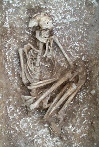
We might never be sure what brought the Amesbury Archer – named that way because of the stone arrowheads burried with him – to Stonehenge, but isotope fingerprinting of his teeth (analysing the oxygen content of the enamel) shows he was born possibly as far away as the Alpina area of central Europe. Burried besides a relative – maybe even his son – who did grew up in southern England he assembled quite some physical injuries during his life. The Amesbury Archer’s grave was discovered in May 2002, 3 miles from Stonehenge. The fact the Amesbury Archer’s grave contained gold hair tresses dated to around 2,400BC, which makes them the oldest dated gold ever found in Britain – as well as the information he grew up in the Alps – evidence of migration – makes him one of the most important finds from the Early Bronze Age in Britain. Did the Archer have a hand in the planning and construction of Stonehenge? Or did he visit the area to seek healing for the constant pain caused by the wound to his knee?
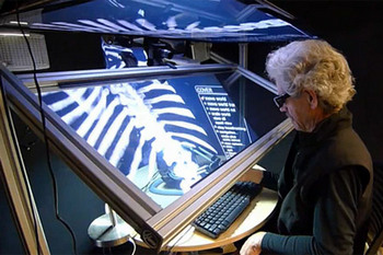
Surely there must be a way to further study this find as to discover possible answers to the many questions still surrounding the Amesbury Archer and his Companion without the need to physically handle – and thus risk damaging – the skeletons? Enter laser scanning: Wessex Archaeology’s technology showcase demonstrates how after the skull and some of the long bones from the Amesbury Archer have been scanned, the 3D model can be used to study and measure their physical aspects without the need to touch the original. And all this with sub-millimetre accuracy. Prior to conservation, the Archer’s skull was captured in 3D with 1,761,689 measurements, allowing for fast and accurate point measurements and cross-sections.
Impressed? I definitely am. If you want to follow Wessex Archaeology’s technical (and other archaeological) adventures, you can find them at wessexarch.co.uk, Flickr and Twitter.
Other interesting – and easy accessible – visualisations of archaeological information are Digital Karnak (using Google Earth) by the UCLA and Ancient Rome 3D. Also, did you know that technology can help us decipher ancient scripts, CT-scans unravel the secrets ancient Egyptian mummies hold and that modern science reveals tons of information about the Book of the Dead? Aren’t you glad we live in the Digital rather than the Stone Age? 😉